The Draft 2040 General Plan
See our Instagram post here!
The draft 2040 general plan contains Sacramento’s current state-of-the-art in urban planning and transit-oriented development guidelines. More ambitious than any past general plan, this new plan gives me hope that we can recover long-forgotten methods of building sustainable, walkable, and strong communities which leverage transit as a wealth multiplier.
The draft plan defines “Transit-Supportive Development” as:
Increased residential and commercial development intensity within one-quarter mile of existing and planned light rail stations, commuter rail stations, and high-frequency bus stops to support more frequent, reliable transit service and vibrant, walkable neighborhoods.
Draft Sacramento 2040 General Plan, p. 3-27
It also has solid language and specific goals that encourage transit oriented development. These five goals explicitly recommend higher residential density and mixing of land uses near transit stations:
- LUP-2.4 – Development Intensity Linked to Transit
- LUP-4.1 – Transit-Supportive Development
- LUP-4.4 – Public Uses and Services
- LUP-4.5 – Efficient Parcel Utilization
- LUP-5.3 – Mixed-Use Neighborhood Centers
However, in this area of the General Plan, some maps are included which provide an opportunity for planners to apply these goals up-front:
- The Land Use Proposal map proposes specific land uses at specific locations.
- The Maximum Floor Area Ratio map proposes maximum building densities at specific locations. This is a decent indicator of desired population density.
Lets evaluate these maps to assess how the various transit-supportive goals have been applied.
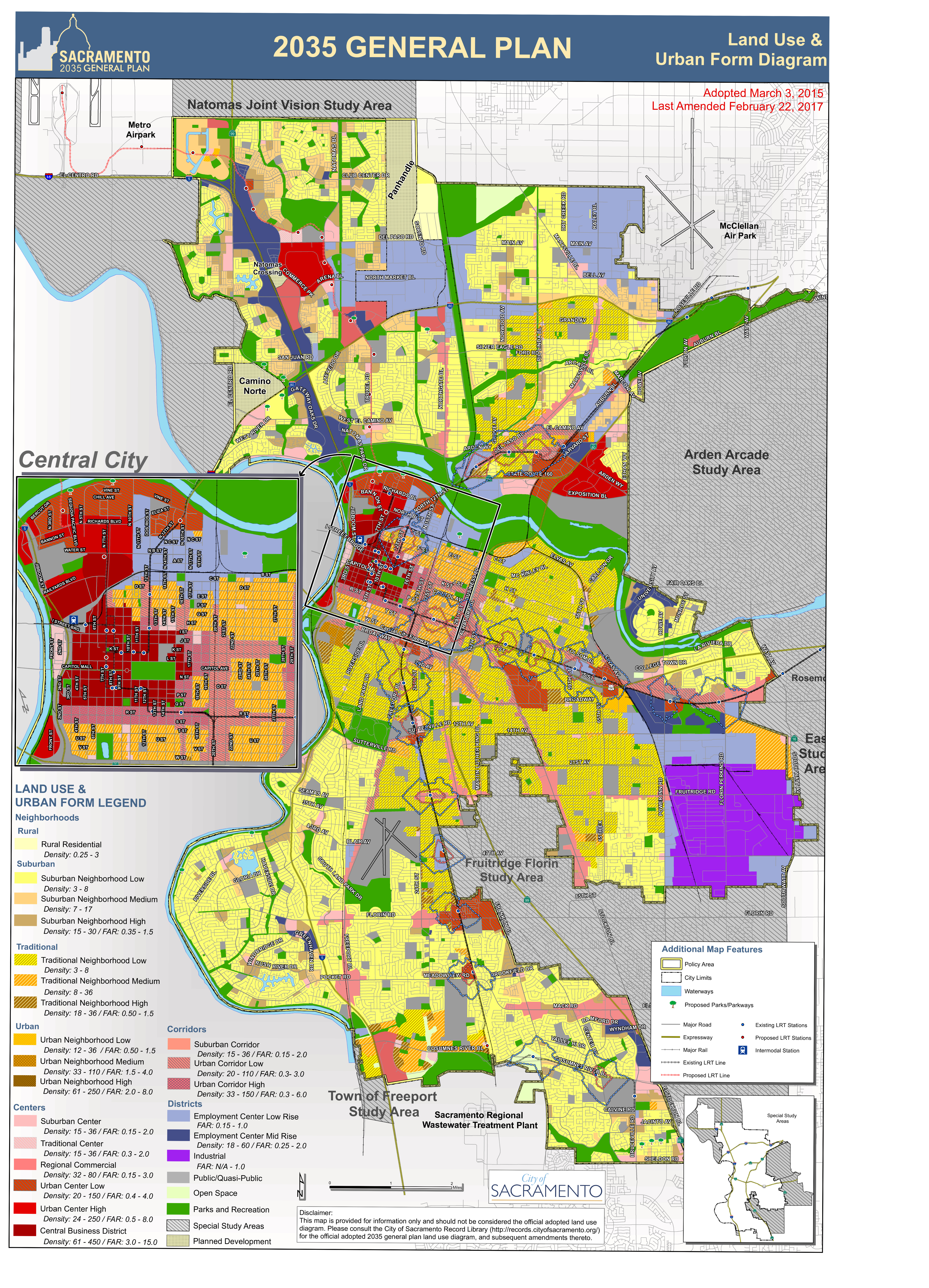
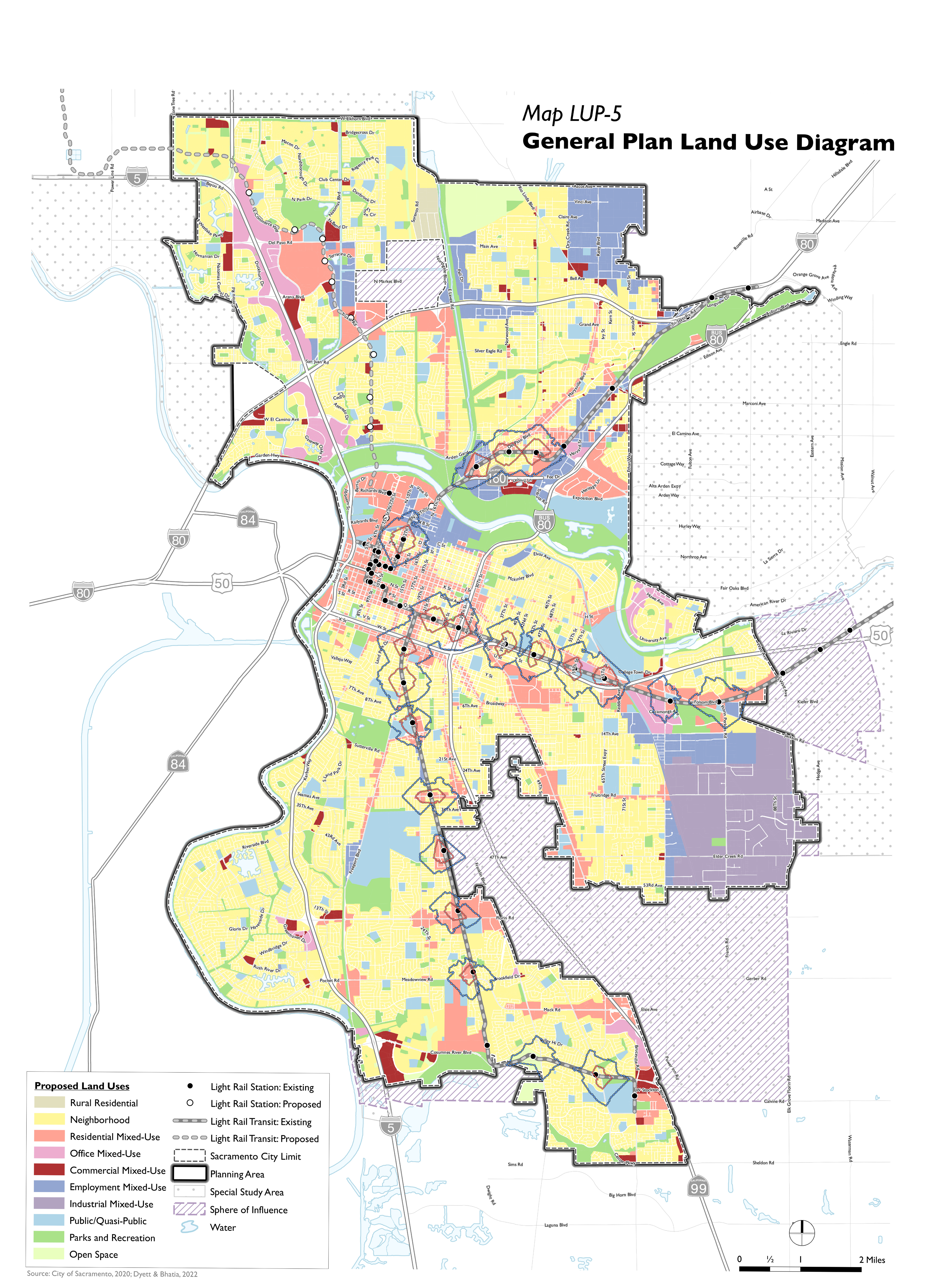
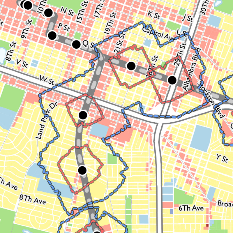
Land Use Proposal Map
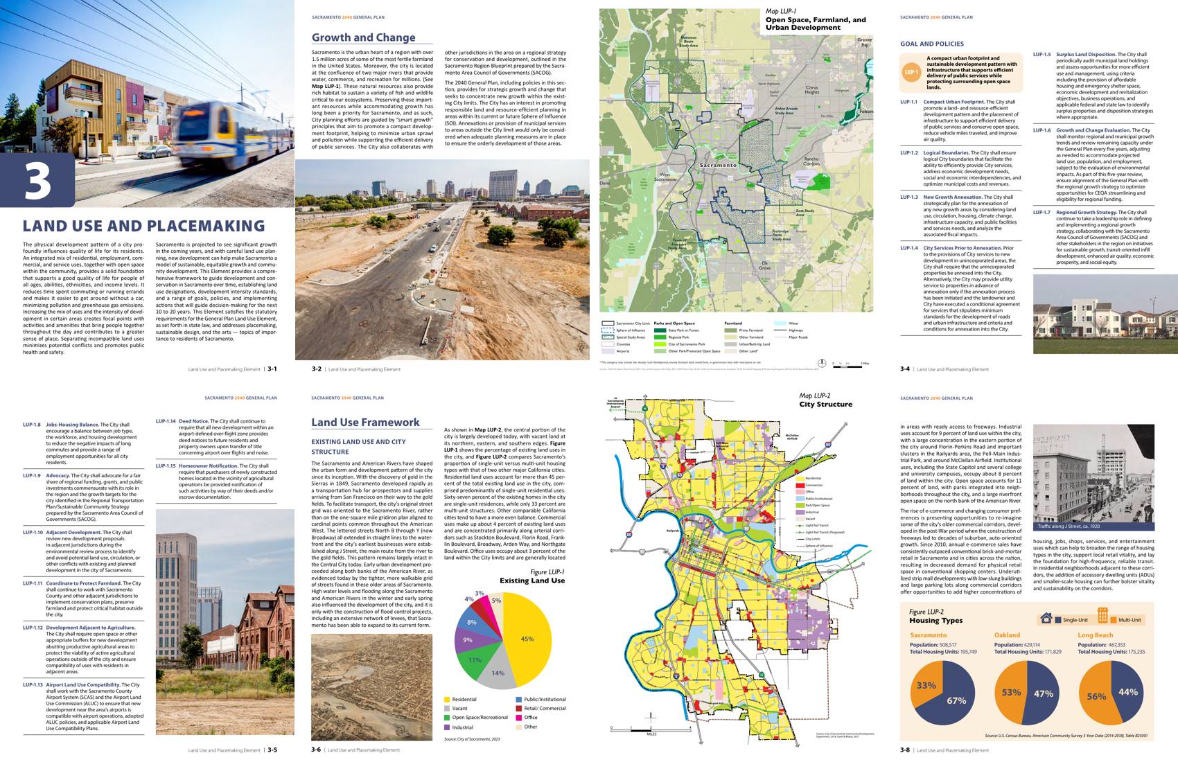
Previous and current general plans have defined Land Use designations such as industrial, open space, commercial, etc. For the purpose of transit-oriented development, we care mostly about the distinction between land uses that allow residential-only by right (yellow) vs. mixed-use by right (red). Furthermore, we care mostly about the land uses that fall inside the 1/4 and 1/2 mile transit walksheds which are drawn using red and blue dashed contours below. These walksheds represent the areas reachable by foot starting from a transit station.
General Plan: Land Use Proposals
Midtown/Land Park/Curtis Park
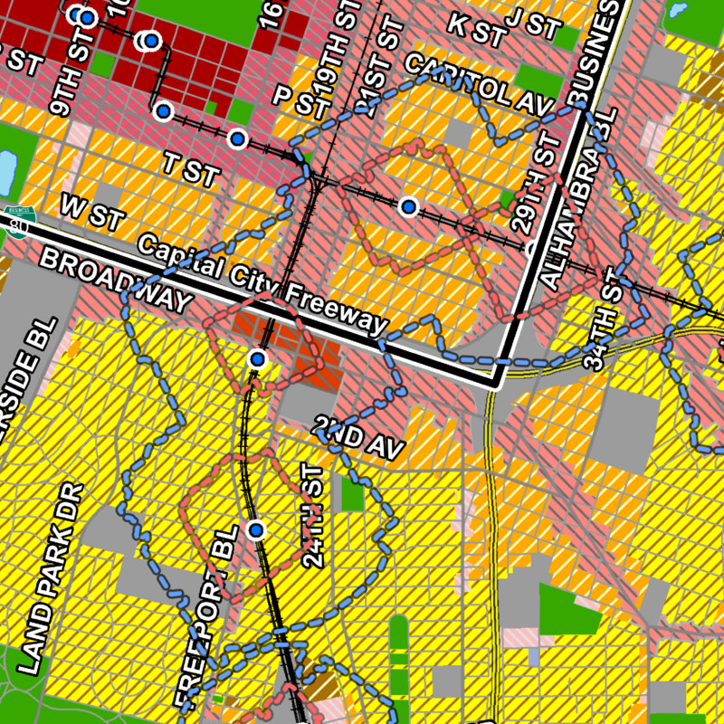
2035 <-
-> Draft 2040
General Plan: Land Use Proposals
East Sac/Elmhurst
2035 <-
-> Draft 2040
Legend:
■
mixed-use by right
■
residential-only by right
╍╍
1/4 mile range
╍╍
1/2 mile range
Drag the sliders above to compare the 2035 general plan land use proposals with that of the draft 2040 general plan. Notice how no additional mixed-use designation has been granted to areas within a 1/2 mile or 1/4 mile walking distance of light rail stations. In fact, no change can be seen anywhere at all! The goals included in the land use element would suggest that at least some parcels within the 1/2 mile walking range should be converted from residential-only to mixed-use by right, but instead we only see business as usual.
Mixing uses is just half the story, so maybe the Maximum Floor Area Ratio (FAR) map is more promising?
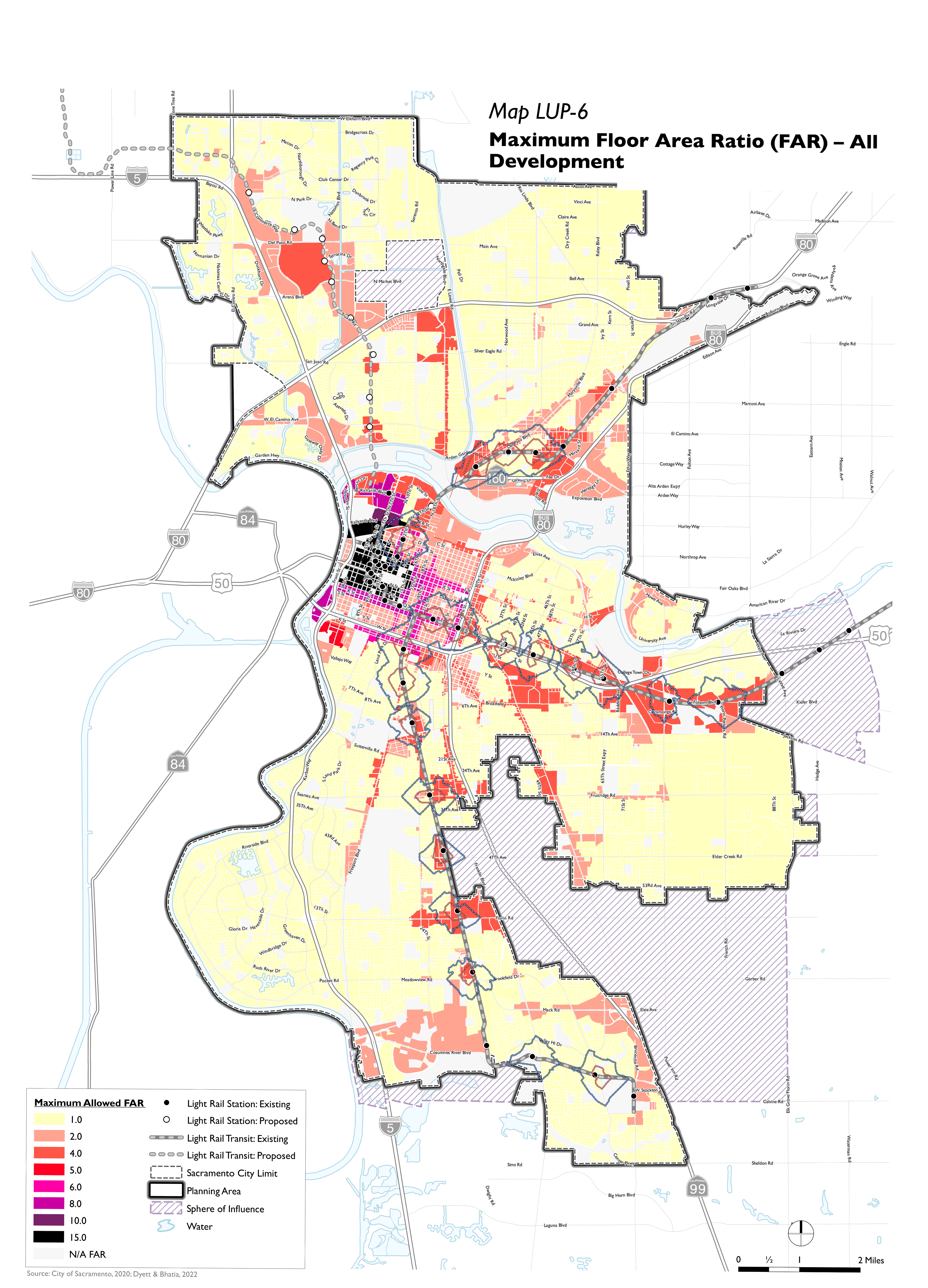
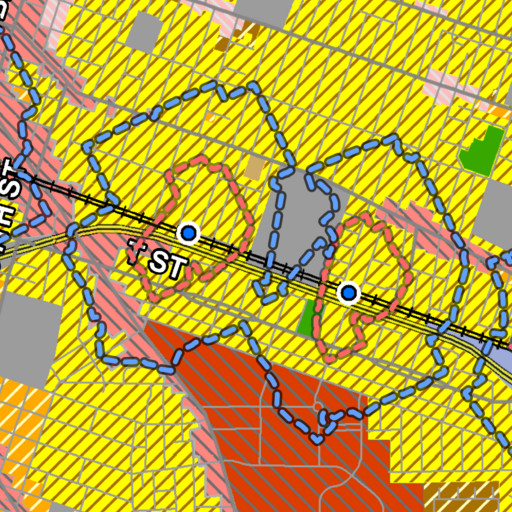
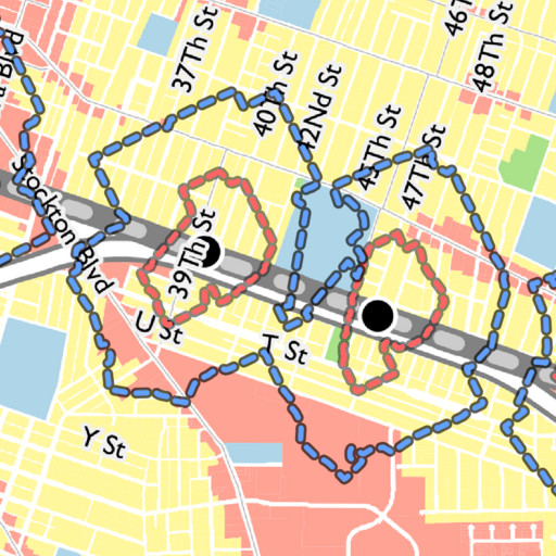
Maximum Floor Area Ratio Map
Floor Area Ratio (FAR) = total floor area of building (including all stories) ÷ total lot area. For example, the following diagram contains three examples of FAR 1.0:
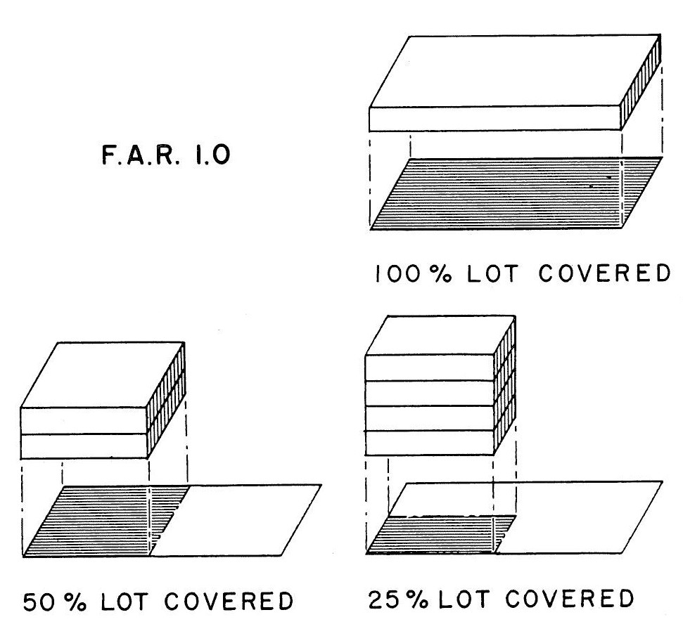
In an FAR-restricted neighborhood, lot coverage can be traded for stories, but population density tends to remain consistent. Typical FAR values in suburban Land Park range from 0.3-0.5, but in Midtown they range from 1.0-3.0, resulting in up to 10x the population density compared to Land Park.
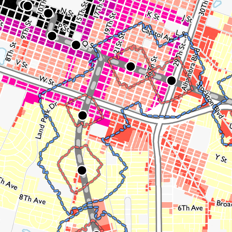
Lets take a close look at the same two locations on the Draft 2040 General Plan Maximum FAR map:
Draft 2040 General Plan: Maximum FAR
Midtown/Land Park/Curtis Park
Draft 2040 General Plan: Maximum FAR
East Sac/Elmhurst
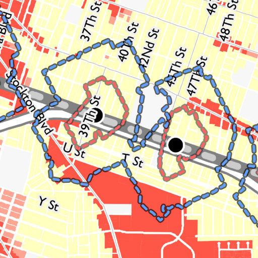
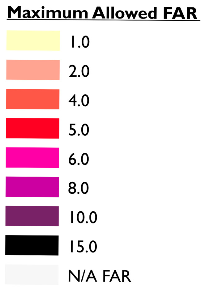
Legend:
╍╍
1/4 mile range
╍╍
1/2 mile range
Once again, just crickets. Maximum FAR is not linked to transit proximity. There is essentially no correlation between Maximum FAR and transit walkshed outlines. If anything, Maximum FAR is more strongly correlated with stroads such as Broadway and Stockton Blvd, yet nobody ever asked for “Stroad-oriented development”!
How to NOT do transit-oriented development
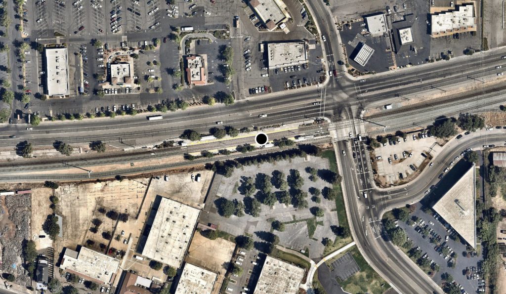
College Greens Station
Image © Mapbox Satellite
Despite flowery language and exciting new goals around transit oriented development in the draft Sacramento 2040 general plan, neither mixed-use development nor increased residential density are explicitly applied near transit in the same document. The general plan presents a rare opportunity to meaningfully shift the needle on car-dependency and fiscal solvency of our city; when the general plan is vague and self-conflicting on matters of land use and density, 30+ light rail stations outside the central city may experience a 5-year development setback. Meanwhile, the progression of housing insecurity, climate change, and accumulation of car-infrastructure liabilities are not going to wait.
How to enable transit-oriented development
Sacramento has many options for enabling more transit-oriented development, including but not limited to:
- Instituting parking maximums near transit,
- Relaxing setback requirements near transit,
- Relaxing minimum lot sizes near transit,
- Initiating a missing middle housing study (great start!),
- Enhancing pedestrian and cycling access to expand reach of transit,
- Performing station-specific reports to help identify opportunities for developing vacant lots and parking lots, e.g. Marconi Station Report,
However, with the 2040 general plan draft review phase coming to an end, here are our recommendations for how every type of stakeholder in a city can boost adoption transit-oriented development in Sacramento today:
If you are city staff: At this critical time, make sure the 2040 General Plan reinforces the stated goals of linking development intensity to transit. In the Land Use Proposal and Maximum FAR maps, apply one additional increment of development intensity to parcels within a 1/2 mile walk from any light rail station, and two additional increments of intensity to parcels within a 1/4 mile walk. For your convenience, see the complete walkshed maps in the Appendix at the bottom of this article.
If you are an elected representative, amplify the voices of constituents who are pushing for a less car-centric city, and support staff to make those changes through the lens of fiscal solvency.
- Bring up these issues with your constituents. Listen to the growing population of pent-up young people who are tired of living in sleepy suburbs, middle-aged people who are tired of being stuck in traffic and hunting for parking, and elderly people whose next drivers license renewal could be their last. Listen to people who can either afford housing or a car, but not both at the same time. Appeal to parents whose children have lost most of their independence since the ’70s and who continue to experience unnaturally high rates of developmental issues due in part to noise and air pollution from cars.
- Appeal to the city staff who are struggling to balance their books without taking on debt. Talk to them about how planning for and legalizing mixed-use density near transit is a critical way to reduce city expenses while simultaneously boosting revenue by leveraging transit as a wealth multiplier.
If you are a resident, take some time to voice your opinion to city staff and city council directly.
- Right now is a critical time. Give your feedback on the Draft 2040 General Pan by going to http://sac2040gpu.org/ and clicking on the self-guided workshop.
- Attend the August 22nd City Council meeting at City Hall or on Zoom to address both the city staff and city council simultaneously. Give a 1-2 minute oral comment about your support of the land use and density recommendations covered in this article.
Gentrification
Before any of you jump out of your seats with concerns about being priced out of your neighborhood, remember that including these changes in the general plan won’t cause redevelopment overnight. The next time a property owner within a transit walkshed wants to build incrementally higher density or mixed-use, the city planners will be less of an obstacle if they can reference a more transit-oriented general plan. This slow, incremental change is referred to as “gentle density” by Strong Towns, and is an approach which will tend to transform urban areas organically over time to become more livable without causing disruptive gentrification.
“No neighborhood should be subjected to radical change, but also no neighborhood should be exempt from change.”
– Strong Towns
As a transit-oriented neighborhood intensifies, the value-add of owning and operating a car diminishes. The average cost of owning and driving a car in California in 2023 is over $500 per month (or $894 per month for new cars). Denser, mixed-use development patterns unlock a substantial opportunity for some people to go car-free, canceling their largest expense after housing. It will also open up new housing and job opportunities for people who already do not own a car but struggle finding nearby jobs.
Furthermore, if higher-intensity development was encouraged more universally, walkability will be a trait shared by ever more places in Sacramento, increasing supply where there is high demand to live. When we self-impose a scarcity of nice places, we self-impose gentrification. Thus, it is not enough to only allow transit-oriented development at three or four select stations—all 30 light rail stations outside the central grid deserve transit-oriented development.
Appendix