See our Instagram post here!
“This morning I took public transit from my apartment in Alkali Flat to American River College. I usually swing by G Street Cafe for breakfast on the way to the Alkali Flat station. But today is Saturday and many downtown-serving restaurants are closed on weekends, so I decided to skip breakfast. It takes a while to cross 12th Street safely, but I managed to jaywalk it so I wouldn’t miss the train.
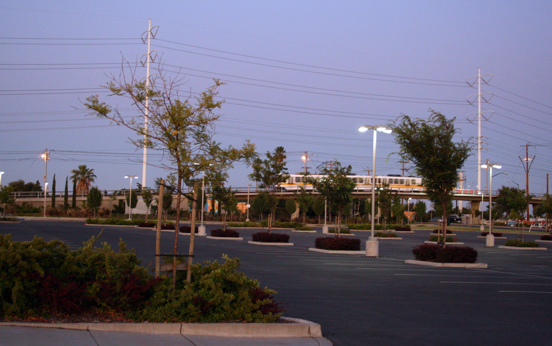
“The train today was pretty empty – it’s a weekend after all. Before arriving at Watt / I-80 station, I put in my earphones in anticipation of the freeway noise, but I realized only after disembarking that I forgot to prepare myself for the distinct freeway smell, a thick mix of smog and tire dust that quickly dries out my nose and throat. The station platform is located in the center divider of the I-80 freeway and underneath Watt Avenue. The elevators are still out of commission, so I climbed 3 flights of stairs to pick up the bus on Watt. It was a mellow 85°F, typically manageable under the tree canopy where I live, but at the tree-less overpass of Watt Avenue and I-80, it felt 10 degrees hotter.
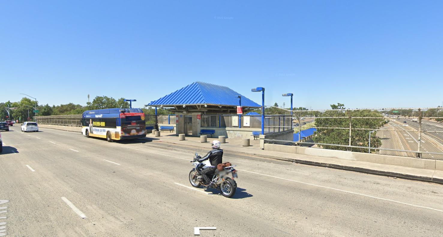
Image © Google
“The bus arrives at 30-minute intervals, but luckily today I was only waiting for a couple of minutes. Halfway to campus, my stomach started growling, so when I saw a bubble tea shop through the bus window, I requested to get off. I’m typically not so spontaneous with my commute! Getting to the shop involved a 1/8 mile detour to the nearest crosswalk. Once I finally got back to the bus stop with my tea, I still had 20 minutes before the next bus. Luckily, five houses down there was a tree to stand under until the bus arrived. Once I got to campus, I beelined clear across the empty parking lot to reach my building.”
This is a true story I heard from a local Sacramento resident. This story illustrates the missed opportunities in both mixed-use high-density development and poor planning in transit-oriented development.
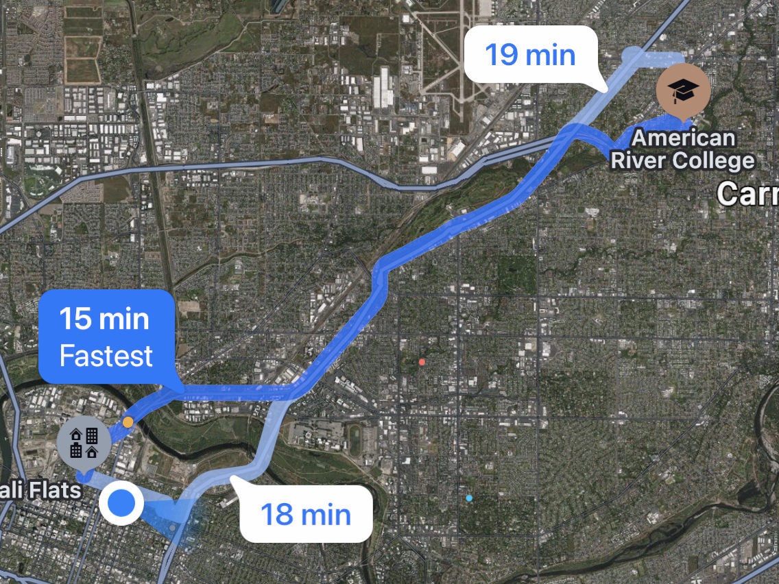
This resident had to traverse unsafe street crossings and spend over 1-hour switching transit methods 3 times to go ~8 miles. And they had to do it without breakfast! We can do better.
What is Transit Oriented Development?
According to Wikipedia:
Transit-oriented development (TOD) is a type of urban development that maximizes the amount of residential, business and leisure space within walking distance of public transport.
In simple terms:
Successful transit needs two things: people to ride it and destinations people need to go.
Not Just Bikes and Strong Towns: What America Keeps Getting Wrong About Public Transit
For visual learners, the Seattle Planning Commission clarifies what transit-oriented development does and does not look like from a land use perspective:
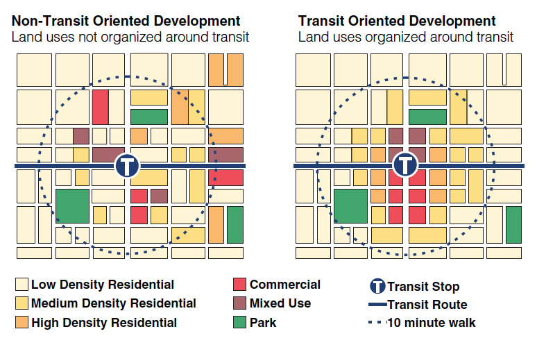
Take note of the absence of “low density residential” land uses near the transit stop on the right-hand side. First, mixed-use and commercial land uses are prioritized near transit, followed by high, medium, then low-density residential land uses farthest away from transit.
What is “walking distance” from transit?
Most language used in Sacramento local policy aim for a 1/4 mile walking distance:
The City shall encourage increased residential and commercial development intensity within one-quarter mile of existing and planned light rail stations, commuter rail stations, and high-frequency bus stops to support more frequent, reliable transit service and vibrant, walkable neighborhoods.
Draft 2040 GP, LUP-4.1
Meanwhile, California bills SB 9, SB 10, and AB 2097 define “Transit-rich areas” to mean any parcel within 1/2 mile of a major transit stop.
Therefore, typical walking distances observed in policy documents range from 1/4 mile to 1/2 mile. Here are a couple examples of 1/4 mile and 1/2 mile walking distances from light rail stations:
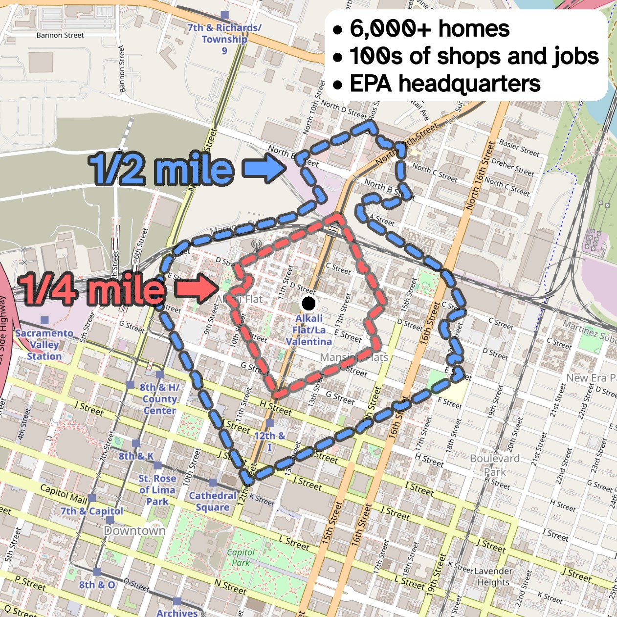
Alkali Flat Station Walksheds
Map data from OpenStreetMap
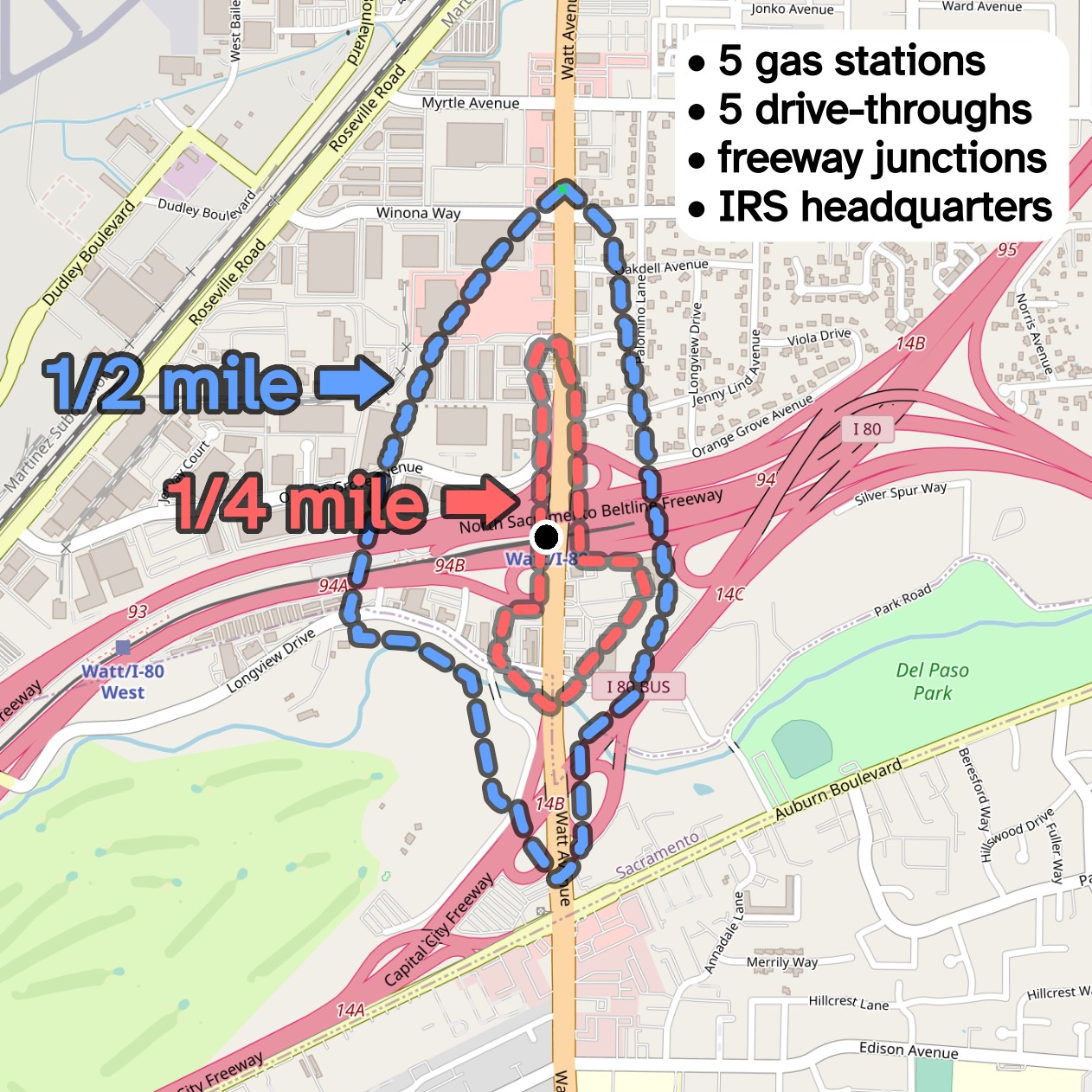
Watt / I-80 Station Walksheds
Map data from OpenStreetMap
Can you guess which of the two development patterns are more transit-oriented? One of the stations has over 1000 households within a 1/4 mile walking distance, while the other has 0 households. One of the stations has hundreds of local shops and employment centers within a 1/2 mile walking distance, while the other has a couple dozen (including 5 gas stations).
Does Transit-Oriented Development Make A Strong Town?
Public transit is a tool that cities can leverage to enhance access to productive, livable places. When public transit is implemented well, it enhances connections between people, businesses, places of leisure, and other everyday necessities.
Public Transit is a wealth multiplier, which is to say that it rewards a city with more value added than the initial investment. Productive, livable places can also stand alone, but transit can serve to protect our collective investment in these places.
While Strong Towns is generally supportive of public transit, they do assume a cautionary stance around transit-oriented development. Investing in transit infrastructure to serve an underdeveloped location and betting on higher-intensity development to follow is an unnecessary financial risk for local government. Strong Towns would instead advocate building transit to serve pre-established high-intensity developments where people tend to congregate already, i.e. development-oriented transit.
This cautionary guidance may have been useful 40 years ago when Sacramento light rail was still in planning, but now the investments have been made and a mature network of light rail lines serve much of the Sacramento region regardless of development intensity near light rail stations.